Ultra Trail Santo Antão 2026
Ultra Trail Santo Antão (UTSA) 2026: 100km+ with 7,000m D+ through Cape Verde's most dramatic island. Cabo Verde Trail Series. December 5.
Information
Contact
Formats
Practical information
Description
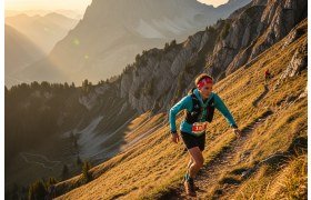
Volcanic Ultra-Trail in the Atlantic
The Ultra Trail Santo Antão (UTSA) is an extraordinary ultra-trail event on Santo Antão, the most mountainous and dramatic island of the Cape Verde archipelago. Part of the Cabo Verde Trail Series, this inaugural edition challenges the toughest and best-prepared runners with over 100 kilometres and 7,000 metres of elevation gain through one of the most spectacular volcanic island landscapes in the Atlantic Ocean.
Santo Antão is a volcanic island of extreme contrasts — from the lush, tropical Paúl Valley with its sugar cane terraces and banana plantations to the barren, moon-like landscapes of the island's arid western coast. The UTSA traverses the full spectrum of this dramatic island, climbing from sea level to ridgelines above 1,500 metres along ancient cobbled paths and vertiginous mountain trails that have connected the island's communities for centuries.
Course and Format
100+ km — The Ultra (7,000m D+)
Starting at 16:00 from Paúl, the UTSA covers over 100 kilometres with a staggering 7,000 metres of cumulative elevation gain. This makes it one of the steepest ultra-trail races in the world relative to its distance — averaging 70 metres of climbing per kilometre. The course follows the ancient stone-paved trails that crisscross Santo Antão's volcanic ridges and deep valleys, offering breathtaking views of the Atlantic Ocean, neighbouring islands and the dramatic interior valleys.
The late-afternoon start means significant portions of the race are run in darkness, adding navigational challenge and atmosphere to an already demanding course. The terrain includes cobbled mountain paths, exposed ridgeline trails, steep valley descents and coastal tracks.
Terrain and Difficulty
Santo Antão's terrain is characterised by volcanic rock, ancient cobbled trails (the island's historical road system), extremely steep gradients and dramatic exposure. The island's trails were built to connect communities across nearly vertical terrain, resulting in paths with sustained gradients that would be considered extreme by European trail standards. The cobblestones, while providing grip, are demanding on feet and joints over long distances.
The climate is subtropical, with temperatures ranging from warm at sea level to cool and potentially foggy on the ridgelines. December is the dry season, with generally favourable conditions, though wind on exposed ridges can be a factor.
Practical Information
- Getting there: fly to São Vicente (VXE), then 1-hour ferry to Santo Antão — there is no airport on Santo Antão
- Climate: December is dry season — warm at sea level (25-30°C), cooler at altitude (15-20°C)
- Terrain warning: the cobbled trails and extreme gradients demand strong ankles and technical footwear
How steep is the Ultra Trail Santo Antão?
With 7,000 metres of elevation gain over approximately 100 kilometres, the UTSA averages about 70 metres of climbing per kilometre — making it one of the steepest ultra-trail races in the world. The course follows ancient mountain paths that were built to cross nearly vertical volcanic terrain, with many sections featuring sustained extreme gradients.
How do I get to Santo Antão?
Santo Antão has no airport. Fly into São Vicente island (Cesária Évora International Airport, VXE), then take the 1-hour ferry from Mindelo to Porto Novo on Santo Antão. International connections to São Vicente are available via Lisbon, Praia (Santiago island) or other Cape Verde islands.
What is the terrain like on Santo Antão?
The trails are largely ancient cobbled mountain paths built by hand over centuries. The terrain ranges from lush tropical valleys with banana and sugar cane plantations to barren volcanic ridgelines and arid coastal sections. The cobblestones provide good grip but are physically demanding over ultra distances, and the extreme gradients require strong hiking and descending skills.
Share it with one of your triathlete friends. 🙏